
TERRA - Intro to Remote Rock Mass Characterization
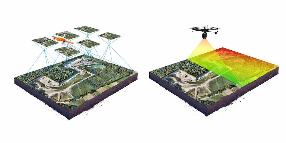
Comparison between laser scanning and photogrammetry
Comparison
Tomás R & Li Z 2017 . Earth Observations for Geohazards: Present and Future Challenges. Remote Sens. 2017, 9, 194.
Laser scanning and photogrammetry are both techniques used in the field of remote sensing and geospatial analysis, but they employ different principles to achieve similar objectives of capturing 3D spatial information. Here's a comparison between the two:
1. Principle:
- Laser Scanning: Laser scanning, including LiDAR and Terrestrial Laser Scanning (TLS), uses laser pulses to measure distances to objects. It emits laser beams and measures the time it takes for the beams to return to the sensor, allowing for precise distance measurements.
- Photogrammetry: Photogrammetry involves capturing images from different angles and processing them to reconstruct the 3D structure of objects or landscapes. It relies on the principle of triangulation, where overlapping images of the same object from different perspectives are used to derive depth and spatial information.
2. Data Collection:
- Laser Scanning: Laser scanners emit laser pulses and record the time taken for these pulses to return, resulting in precise point cloud data of the object or terrain surface.
- Photogrammetry: Photogrammetry requires capturing multiple overlapping images of the same area using cameras mounted on drones, aircraft, or ground-based platforms. These images are processed to generate point clouds or digital surface models (DSMs).
3. Accuracy and Resolution:
- Laser Scanning: Laser scanning provides high accuracy and resolution, especially in capturing detailed geometric information of objects and terrain features. It can accurately capture fine details and is often used for engineering, urban planning, and topographic mapping applications.
- Photogrammetry: The accuracy and resolution of photogrammetry depend on factors such as camera quality, image overlap, and ground control points. While it can achieve high-resolution models, the accuracy may vary depending on the quality of the imagery and processing techniques.
4. Coverage and Efficiency:
- Laser Scanning: Laser scanning is ideal for capturing detailed 3D data of specific objects or areas but may be less efficient for large-scale mapping due to the limited coverage area per scan.
- Photogrammetry: Photogrammetry can cover larger areas more efficiently, especially when using aerial imagery captured by drones or aircraft. It is suitable for mapping extensive landscapes or infrastructure projects.
5. Cost and Equipment:
- Laser Scanning: Laser scanning equipment, including LiDAR sensors and TLS devices, can be expensive to purchase and operate. Additionally, processing and analyzing point cloud data require specialized software and expertise.
- Photogrammetry: Photogrammetry equipment, such as cameras and drones, may be more affordable and accessible. However, processing software and computational resources for image stitching and 3D reconstruction may still incur costs.
In summary, laser scanning offers high precision and accuracy for detailed 3D modeling of objects and terrain, while photogrammetry provides efficient and cost-effective solutions for large-scale mapping and monitoring applications. The choice between the two techniques depends on the specific requirements of the project, including scale, accuracy, budget, and available resources.